A guide to finding Somerset maps online
Some historic maps held at the Somerset Heritage Centre have been made available online through two websites: the Somerset Historic Environment Record and Know Your Place.
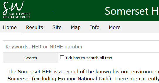
Somerset Historic Environment Record (https://www.somersetheritage.org.uk/)
Geographical area: Somerset and B&NES
Maps available:
- Tithe maps, c. 1840 (see below for exceptions)
- 1st edition Ordnance Survey maps, c. 1888
- Ordnance Survey Town Plans, c. 1888 (large urban areas only)
- 2nd edition Ordnance Survey maps, c. 1904
- 2nd edition revised Ordnance Survey maps, 1910-1940 (incomplete coverage)
- Ordnance Survey National Grid maps, 1940s onwards (incomplete coverage)
- Current Ordnance Survey maps
Other information available:
- RAF aerial photographs, 1946 (excluding Bath City)
- Tithe map information (for parishes in Somerset and B&NES)
- Monuments and fieldwork (excluding Exmoor National Park)
- Legal designations (excluding Exmoor National Park)
- Conservation areas (excluding Exmoor National Park)
- Historic landscape character (excluding Exmoor National Park)
How to find the maps
From the homepage click on map on the toolbar
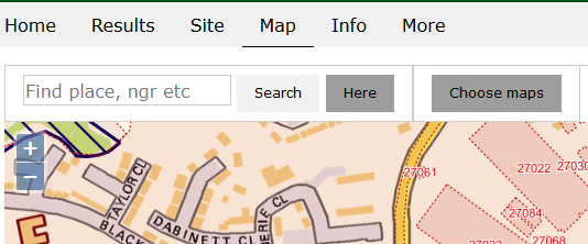
The map will default to a modern Ordnance Survey map centred on the Somerset Heritage Centre, to find the place you would like to view a map for, search in the box. A further box will then pop up, click on the name of the place most relevant to you. Or if you have location services on your computer click on ‘Here’ to centre the map to your location. To view a different map, click on ‘Choose maps’.
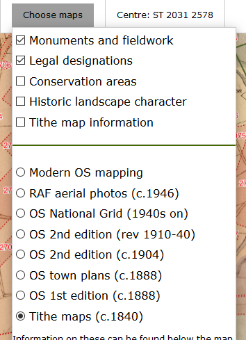
Then from the list of possible maps, click in the circle next to the map you would like to see.
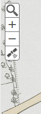
You can navigate around the map, using the click and drag feature on your mouse and zoom in and out using a rollerball mouse, or with the +/- signs in the top left corner.
To see the Historic Environment Record details on a property or landscape feature, make sure ‘Monuments and Fieldwork’ are selected in the drop-down options, and then on the map click on the red numbers. To go to the full report, click on the relevant text.
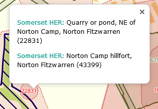
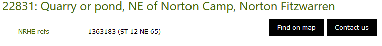
The full report will navigate you away from the maps, to return click on ‘Find on map’ on the right handside.
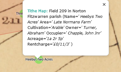
The ‘Tithe map information’ will provide you with details from the tithe apportionment (owner, occupier, name of lands, cultivation, acreage and rateable value). To view the information, select the option from the ‘Choose maps’ drop-down list, and then the field names will be displayed (there is a lot of information to be loaded, so there may be a small delay, zooming in on the map can help make them appear), then click on the green dot with the field name.
Know Your Place
Geographical area:
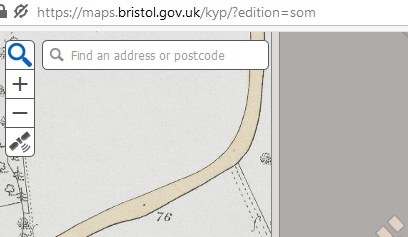
- Somerset https://maps.bristol.gov.uk/kyp/?edition=som
- North Somerset https://maps.bristol.gov.uk/kyp/?edition=nsom
- B&NES https://maps.bristol.gov.uk/kyp/?edition=banes
Maps available:
- A small selection of estate maps from the 1700s
- Enclosure awards (incomplete, see notes below)
- Tithe maps, c. 1840 (see below for exceptions)
- Goad Insurance Plans, 1887 (incomplete coverage, mainly Bath area)
- 1st edition Ordnance Survey maps, c. 1888
- Ordnance Survey Town Plans, c. 1888 (large urban areas only)
- 2nd edition Ordnance Survey maps, c. 1904
- 2nd edition revised Ordnance Survey maps, 1910-1940 (incomplete coverage)
- Ordnance Survey National Grid maps, 1940s onwards (incomplete coverage)
- Current Ordnance Survey maps
Other information available:
- Community layer, which includes images and information uploaded by volunteers and individuals
- Historic Environment layer (HER)
- Boundaries
How to find the maps
The maps for each area will centre on the Somerset Heritage Centre for Somerset, the centre of Bath City for B&NES and Weston super Mare library and Town Hall for North Somerset, to find the place you would like to view a map for, click on the magnifying glass in the top left hand corner, and then search for the place name or postcode in the box.
The default view will show a current Ordnance Survey map as the basemap, and the 1st edition Ordnance Survey map as the comparison map. You can slide the view to see more of the comparison map, by clicking and dragging the box half-way down the dividing bar. This allows you to compare two periods of mapping.
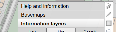
To change the maps shown, click on ‘Basemaps’ at the top righthand side.

To change the left-hand map, click on ‘Comparison map’, to change the right-hand map click on ‘Main map’.
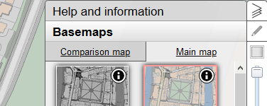
Then click on the map series you would like to view.
You can navigate around the map, using the click and drag feature on your mouse and zoom in and out using a rollerball mouse, or with the +/- signs in the top left corner.
You can close the map options by clicking on the triangles in the top right-hand side. Click here again to re-open them.
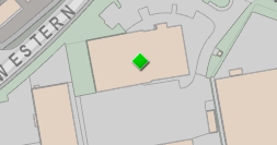
The Community Layer includes images and information uploaded by volunteers and individuals. Information added through the community layer is indicated by a green diamond. Click on the diamond to view the details or added images. You will need to be in the relevant website for your area to see the Community Layer.
Tithe map exceptions
The following tithe maps are not currently available online, however, microfiche copies are available at the Somerset Heritage Centre.
- Ashbrittle
- East Lydford
- Norton Hawkfield
- Poyntington (now Dorset)
- Sandford Orcas (now Dorset)
- Seaborough (now Dorset)
- Stratton on the Fosse
- Trent (now Dorset)
- Wells St Cuthbert overall map (ref. D/D/rt/M/370/14)
If the map is not showing on Know Your Place, check that you are in the relevant website for the area.
Tithe maps were not created for the following parishes:
- Bath SS Peter and Paul
- Bath St James
- Bath St Michael
- Charterhouse on Mendip
- Exmoor
- Rodden
- Witham Friary
Full details of tithe map exemptions and alternative maps can be found on our online catalogue (ref. D/D/rt/M).
Enclosure awards (ref: Q/RDE)
The majority of the enclosure award held at the Somerset Heritage Centre are available on Know Your Place, divided by the pre-1840 and post-1840 awards. Enclosure awards typically only show the lands subject to Enclosure, and therefore may not show the whole parish. The maps which only show very small sections of the parish have been omitted from inclusion on Know Your Place.
Other online maps
Ordnance Survey maps for the whole country, both the pre-war County Series, and the post-war National Grid maps can be found on the National Library of Scotland’s website, search the internet for ‘National Library of Scotland maps’.
The Map House website, also includes historic maps of the whole county, such as Greenwood's 1822 map. Search the internet for the map house and then navigate to English Counties and then Somerset.
Use of maps on the HER and Know Your Place
The online maps are provided for personal research purposes only, if you would like to reproduce these maps in any other form or publication, we ask that permission be requested in writing from the South West Heritage Trust, and further details can be found in our ‘Permission to Use Collections’ research guide.
Details on further use of Ordnance Survey mapping can be found on their website.